The magnificent natural amphitheatre of Alpago achieved its present form following intense, and still active folding which created the Alps.
This folding was not uniform either in time or space and resulted in the older rocks often forming the peaks of the mountains while the more recent, pre-quaternary, are underneath in the basin centre.
This form is known tectonically as “syncline”. The opposite, the “anticline”, where the older rocks are in the centre and lower than the younger ones, is found at the western margin of Alpago between Cugnan and Cadola.In both cases the slope surface almost always corresponds to the dip in the various pre-quaternary strata, particularly in the higher terrain.
The basin of Alpago is open both to the north towards the Piave valley and south towards the Lapisina valley.
These valleys are also of tectonic origin and are full of faults, later carved out by the water of the Piave river and its glacier; the erosion reached a depth of 150 metres below the present infilled bed at Paludi.
In fact the material brought down both by water courses and landslips has filled in many valleys, giving us the present land forms, and is a continuing process.
Some millions of years ago Alpago and nearly all the province of Belluno looked very different, being below present sea level.
Deposits of silt and organic material, which accumulated on the bottom of this marine environment during the Jurassic and Miocene periods, were hardened under the pressure of increasing sediment and then folded to form the present configuration.
The oldest outcropping rocks are Jurassic, deposited 150 to 210 million years ago when a deep, narrow basin was being formed between the platforms of Trentino in the west and Friuli in the east.
On the whole in this area the older rock formations are more stable, being prevalently of limestone and dolomite which have strong physical and mechanical properties.
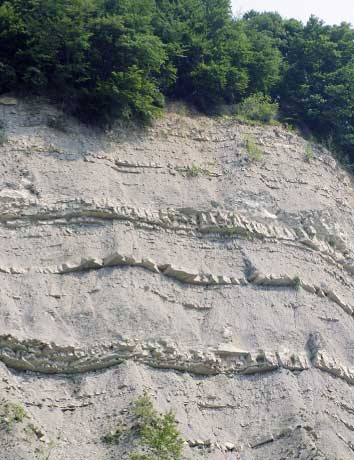
The intermediary zone of flysch mainly consists of Eocene marne, clay and sandstones.
The alternation of erosion resistant sandstone and limestone with softer clay and marne has resulted in the “hog’s back” shape of some slopes in the south-west unlike the rest of the landscape.
The term “hog’s back” (cuesta) refers to a hill with one gentle slope parallel to the dip in the strata while the slope on the opposite side is much steeper.
In Alpago the more recent development of the landscape can be attributed to erosion by streams and landslips.
The Flysch layers (Eocene) and quaternary deposits (moraine and glacier outwash) are most vulnerable to erosion because of their clay and silt content whose physical and mechanical properties are greatly reduced when wet.
This explains the connection between rainfall and landslips.
Some landslips worth mentioning are the Tessina, over 100 metres in depth, the one at Lamosano which has affected the village and the one at Fadalto which led to the formation of the Lake of Santa Croce.
Of palaeographic interest is the fact that Alpago in the Cretaceous period (about 70 to 135 million years ago) was covered by a sea outside the reef whereas in the Mount Cavallo-Cansiglio area there was a tropical type of reef which stretched from Mount Cavallo in a south-south-westerly direction almost to the present river Meschio.
Relics of this reef are now found in the areas of Crosetta, Candaglia and Croseraz.
Small variations of sea level followed until about 65 million years ago when, following subsidence, the whole area was immersed and the growth of reef-type organisms was interrupted.
The erosion of the then raised land produced deposits of mudstone, marne, flysch and a series of sandstones. The basin of Alpago, which was under water, was inhabited by shellfish, coral, odontocetus (similar to dolphins), gastropods, sharks, etc.
In the Quaternary period Alpago, like the rest of the area of Belluno, underwent intense climatic variations which affected the enlargement or withdrawal of glaciers.
The apex of the Ice Age saw glaciers up to 800 metres thick covering most of Alpago, as we see from the moraine deposits of the Piave glacier in the last expansion during the Wurm period, found in a circular strip at a height of about 1000 metres, and below the plain at Paludi at 170 metres below sea level.
At the mouths of the side valleys of Val Salatis, Venal di Montanes and Venal di Funes there are moraine deposits made up of local material brought down by local glaciers.
At the head of these valleys there are typical limestone features both on the surface and underground which are even more common on the nearby Cansiglio plateau. This plateau has a vast depression in the centre surrounded by mountains of between 1300 and 1600 metres in height.
The rock has been, and still is, subject to Karst erosion, both mechanically and by chemical/physical agents. The typical Karst formation can be seen in the wide bowl with the side grooves of Valmenera and Cornesega, dolines, blocks of limestone pavement, vertical joints and sinks formed by corrosion.
The variety of rock available in Alpago and its good quality has led to quarrying, begun in ancient times. Prehistoric man used flint, the Romans in the 2nd and 3rd Centuries A.D. used the Fadalto limestone, found at its best at Prandarola on the Cansiglio plateau. Later quarries were opened to extract the Col Indes limestone at Treponti, four at Palughetto, Col Indes and Tambruz.
The Flysch formation provided material for support walls and buildings. Sandstone was used at Puos d’Alpago, S. Martino, Sitran, etc. “Scaglia Rossa” is currently quarried at La Secca and Cornolade, and Fadalto limestone near Tambre and above Chies d’Alpago.